Hysteretic relationships in inundation dynamics for a large lake–floodplain system
Large lake floodplains have important roles in mitigating floods and providing vital habitats for wetland biota. This research explores the hydrology of the extensive floodplains of Poyang Lake (China) to highlight complex, hysteretic relationships in the inundation dynamics, which are controlled by the heterogeneity of the land surface and time-varying exchanges between the Lake, its catchment and the Yangtze River.
A physics-based hydrodynamic model of the system was used to evaluate the development and degree of hysteresis in the relationships between the flooded area, the water storage volume and the water level elevation. The modeling results indicate that the degree of hysteresis varies spatially with point of reference within the Lake. It is noted that a clockwise hysteresis is present for the majority of the Lake, but a counter-clockwise hysteresis is present at the upstream boundary, similar to a river–floodplain behavior. Both the floodplain and the permanently inundated region contribute to Poyang Lake’s volume–stage hysteretic effects. The time-varying inflow from rivers in the catchment is the major factor affecting hysteresis, rather than Yangtze River controls on Lake discharge. As expected, an increase in land surface roughness (representing denser vegetation cover) produced greater hysteresis, most notably in the storage curve and derived mainly from the floodplain region. Hysteresis is an important characteristic of the floodplain hydrology that needs to be incorporated in simpler models of the inundation dynamics to avoid errors of up to 50% in the floodplain water storage.
The current study shows for the first time the hysteretic nature, and its major causal factors, of the hydrology of a large lake–floodplain system. An improved understanding of Poyang Lake floodplain behavior is offered to guide the future development of water management models.
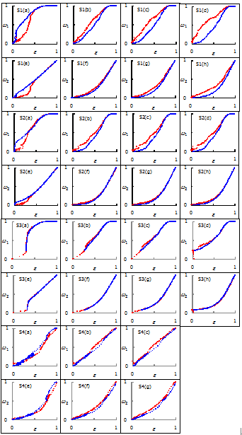
Normalized area-stage and volume-stage relationships for the Lake-floodplain system for Scenarios S1 to S4. Graphs (a) to (d) depict area-stage relationships for Kangshan, Duchang, Xingzi and Hukou stations, respectively. Graphs (e) to (h) show volume-stage relationships for Kangshan, Duchang, Xingzi and Hukou stations, respectively. The red and blue dots represent the rising and falling limbs, respectively. The horizontal axis is normalized water level elevation (e), and the vertical axis is normalized water area (w1) or storage (w2).

Simulated water level changes for S1. (a) and (b) are for water level elevations at rising (2 April, 12 m water level elevation at Xingzi station) and falling (16 November, 12 m water level elevation at Xingzi station) periods. (c) and (d) are for water level change rates at the same times. (e) and (f) are the water depths at the same times. The white area in (e) and (f) within the floodplain denotes water depths less than 0.2 m.
Full-text URL: http://dx.doi.org/10.1016/j.jhydrol.2015.04.068