研究揭示我国两大通江湖泊洪泛区水面变化时空分异模式
Poyang Lake and Dongting Lake are the two largest freshwater lakes in China. The lakes are located approximately 300 km apart on the middle reaches of the Yangtze River and are differently connected through their respective tributary systems, which will lead to different river–lake water exchanges and discharges. Thus, differences in their morphological and hydrological conditions should induce individual lake spatio-temporal inundation patterns. Quantitative comparative analyses of the dynamic inundation patterns of Poyang Lake and Dongting Lake are of great importance to basic biogeochemical and ecological studies.
In this study, using Moderate Resolution Imaging Spectoradiometer (MODIS) satellite imagery and a geographic information system (GIS) analysis method, we systematically compared the spatio-temporal inundation patterns of the two river-connected lakes by analyses of the lake area, the inundation frequencies (IFs) and the water variation rates (WVRs). The results indicate that there was a significant declining trend in the lakes’ inundation area from 2000 to 2011. The inundation areas of Poyang Lake and Dongting Lake, decreased by 54.74% and 40.46%, with an average annual decrease rate of 109.74 km2/y and 52.37 km2/y, respectively. The alluvial regions near Dongting Lake expressed much lower inundation frequencies, averaged over multiple years, than the alluvial regions near Poyang Lake. There was an obvious spatial gradient in the distribution of water inundation for Poyang Lake; the monthly mean IF slowly increased from north to south during the low-water, rising, and high-water periods. However, Dongting Lake expressed a clear zonal distribution of water inundation, especially in the low-water and rising periods. In addition, the WVRs of the two lakes differently changed in space throughout the year, but were in good agreement with the changing processes of water expansion or shrinkage. The different inundation frequencies and water variation rates in the two lakes may possibly depend on many intrinsic factors, including surface discharges from their respective tributaries, river–lake water exchanges and the lakes’ topographical characteristics. These findings are valuable for policymakers because they may lead to different decisions and policies for these two complex river–lake systems.
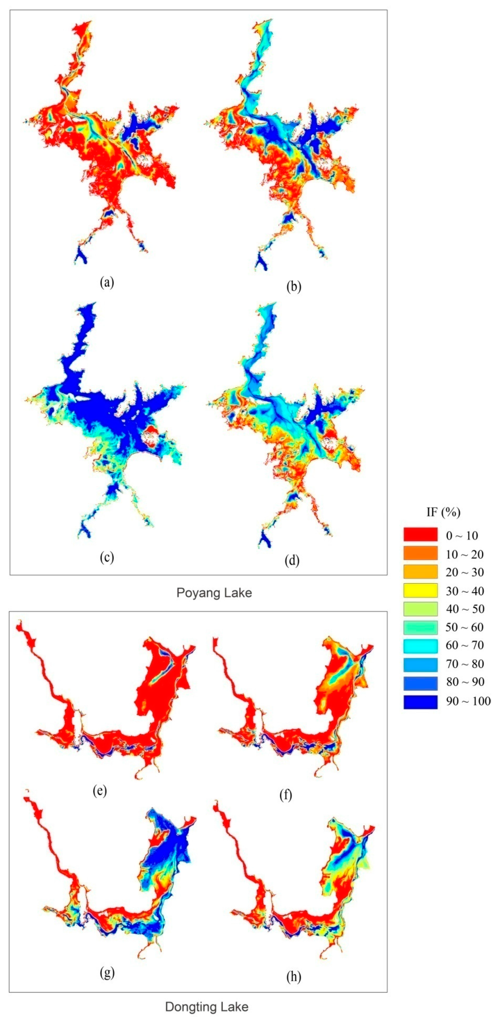
Maps of the evolution of the mean inundation frequency for the two lakes during the different water regime periods: (a–d) Poyang Lake in the low-water, rising, high-water and retreating periods, respectively; and (e–h) Dongting Lake in the low-water, rising, high-water and retreating periods, respectively
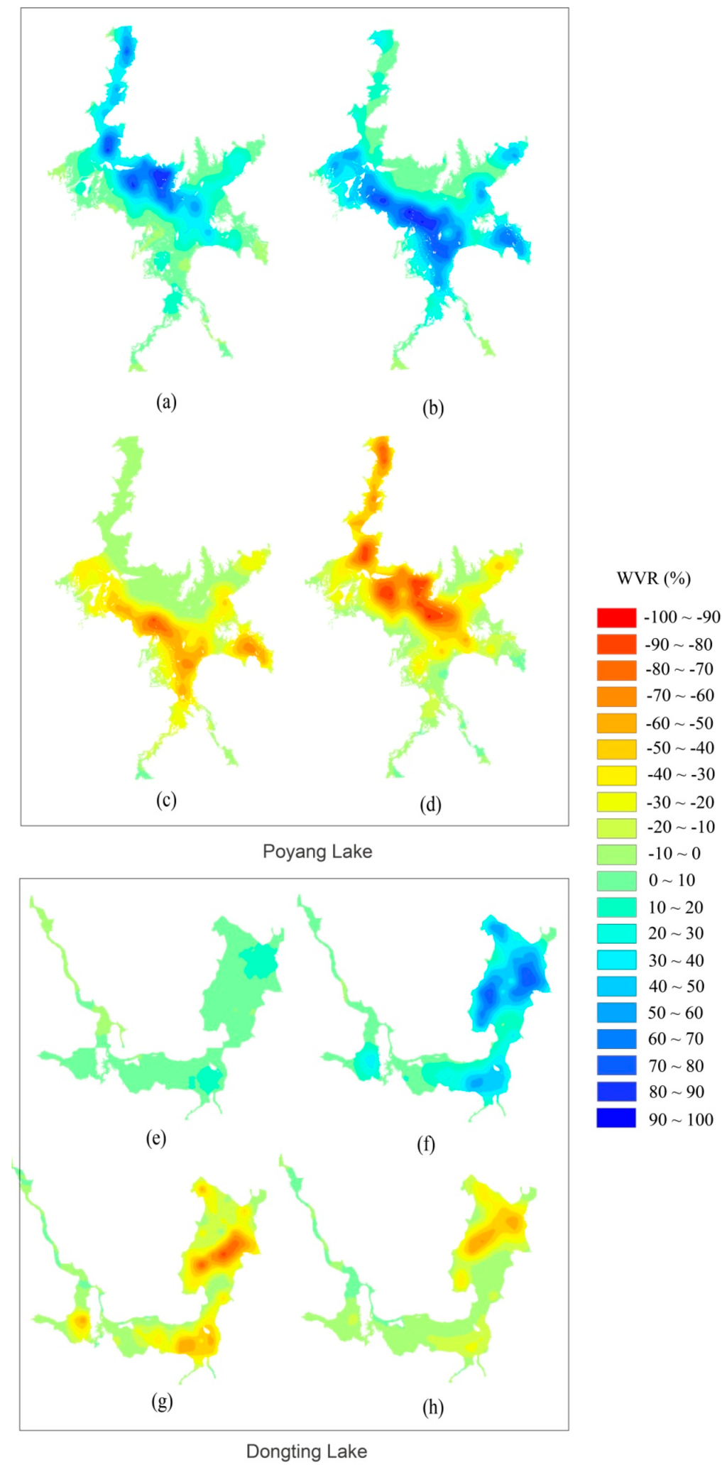
Spatial distributions of the water variation rates of water inundation in the two lakes. Variations in the water surface of: Poyang Lake (a–d); and Dongting Lake (e–h) during the low-water to rising period, rising to high-water period, high-water to retreating period, and retreating to low-water period, respectively. Water expansion is shown in blue, and water shrinkage is shown in red.
文章来源:Wu, GP & Liu, YB. Mapping Dynamics of Inundation Patterns of Two Largest River-Connected Lakes in China: A Comparative Study. Remote Sensing,2016, 8(7), 560; doi: 10.3390/rs8070560.
全文链接:http://www.mdpi.com/2072-4292/8/7/560/htm